


A Side of Park
A Side of Park
Extending the benefits of our parks where San Francisco needs them most

11th and Natoma
The industrial corner of 11th and Natoma in SOMA is about to get a lean, green makeover. Set for groundbreaking in Fall 2025, the 11th and Natoma Park comes at a critical time in SF’s park history. SOMA is a neighborhood severely lacking in public open space. Yet it’s home to the SOMA Pilipinas Filipino Heritage District, the Leather & LGBTQ Cultural Districts, and is designated as an Equity Priority Community. All of these communities (and more) are serviced by only a few small parks.
Historically an industrial and service center for the city, SOMA didn’t have any parks (bar South Park) until the mid-1980s when the Alice Street Community Garden popped up between Harrison and Folsom. The parched ‘park desert’ has only made marginal progress since then, with only 6 spaces serving an estimated population of over 30,000 current residents. That’s one space per 5,000 people! It’s not like SOMA has an Alamo Square either; these six spaces total just 9.1 acres: a tiny green drop (2.24%) within SOMA’s 406-acre pond. Some say park quality is more important than the park quantity. But SOMA lags behind in this metric as well.
According to the FY22-23 Evaluations Report from RPD and the Controller’s Office, District 6 (SOMA, Mission Bay, and Treasure Island) was the outlier—underperforming while the rest of our park system flourishes. While every other district surpassed the 85% quality benchmark (all +/- 2 percentage points from the citywide average of 91%), SOMA, at 82%, fell short of the minimum quality goal and 9 percentage points below its peer districts. In short, the neighborhood needs some green TLC.
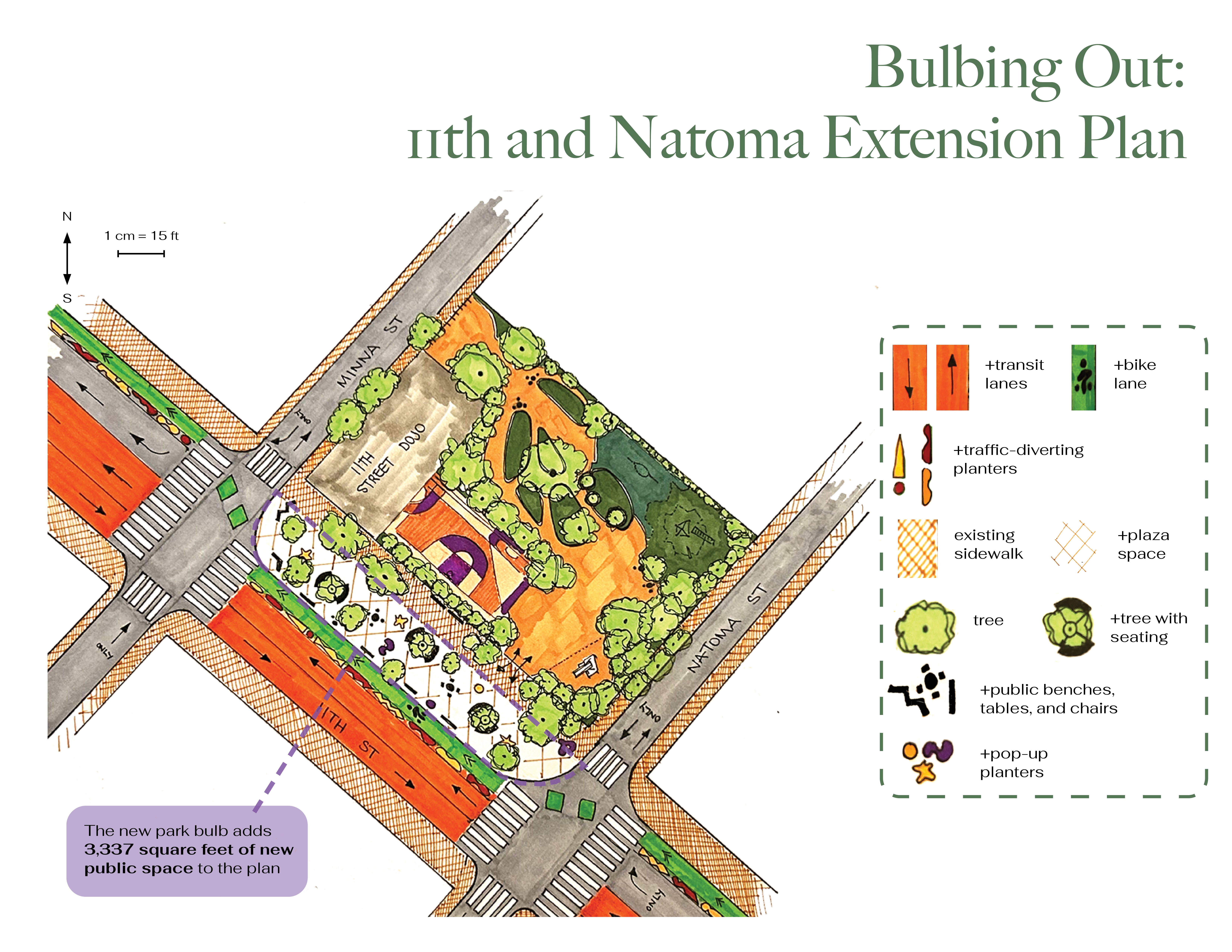
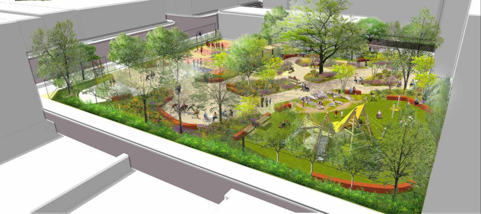
The planned park at 11th and Natoma provides just that, adding another half acre (21,780 sq ft) of passive and active recreation space. The plan looks fantastic: basketball court, two different play structures, and urban canopy a plenty. We say, why stop there?
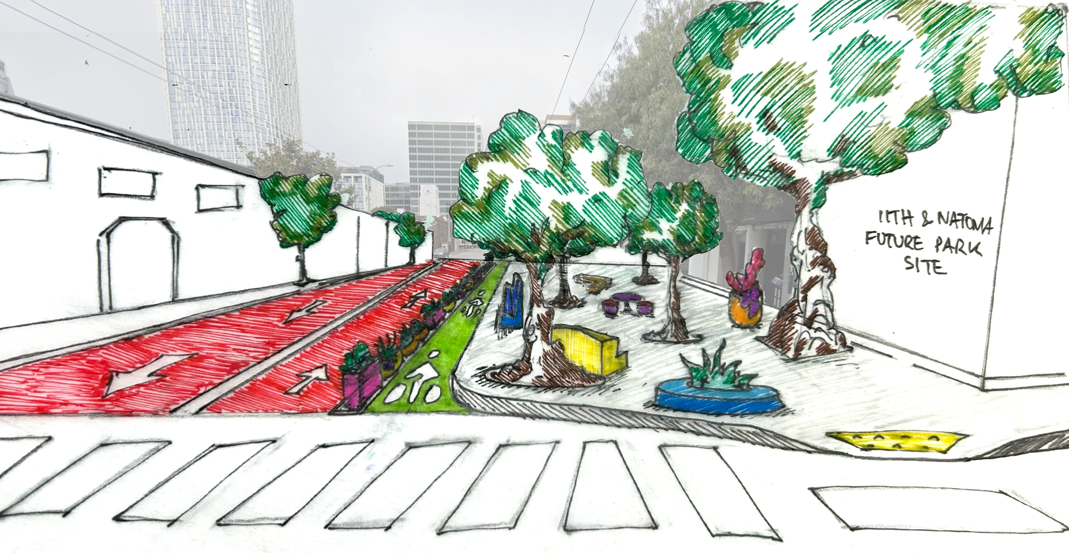
We’re proposing a “bulb out” or park extension that extends into 11th Street to add 3,337 sq ft of public space to this new park. In its current form, 11th Street between Minna and Natoma is 6 lanes wide (60 feet): 3 vehicle traffic lanes (10ft), 2 parking/buffer lanes (14ft northbound, 6ft southbound), and one southbound bike lane (6ft). The 9 and 90 buses that traverse 11th are essential so we left the two farthest west lanes as Bus Rapid Transit (BRT), occupying about half of the road space. BRT lines are separated from a newly extended northbound bike lane by robust planters. With the remaining 24 feet, the sidewalk is “bulbed out” to create a “park extension” that is not 100% park but not 100% street either.

The one-block plaza is meant to encourage a continuation of the tree canopy, public seating, and public art found in 11th and Natoma park, creating a cohesive experience for SOMA’s park-goers and pedestrians. Aside from the user experience, there are also some necessary ecological interventions. The provision of street trees adds necessary shade and stormwater retention infrastructure to a part of the city that can be sweltering during warm days due to the lack of tree cover. In addition, sidewalk planters assist the park’s biodiversity and stormwater goals while making the space feel more protected from traffic.
As you may remember from our 34th Ave Open Street blog from NYC, our streets are living laboratories for public space re-interpretation and activation. When we right-size our relationship with cars, other opportunities for our public realm emerge, and communities soon discover a multitude of enticing alternatives. The extension at 11th and Natoma aims to incorporate some of these alternatives (street trees, planters, seating, public art, etc.) to serve the diverse needs of SOMA’s many communities. In a neighborhood with a limited amount of park space, every inch counts, and the 11th and Natoma Extension, filled to the brim with green amenities, would make this new park count that much more.
In addition to expanding the park, the park extension also eliminates through traffic, making the surrounding blocks more pleasant and providing a unique benefit to the nightlife district a few blocks south. How? Decreased through traffic makes it easier to shut off portions of that street for events, making the area more lively and economically resilient, as businesses would have more flexibility to expand into the streets as needed.
What would it look like to bring these types of benefits to other small parks? Mission Playground provides a great opportunity to find out.
Mission Playground
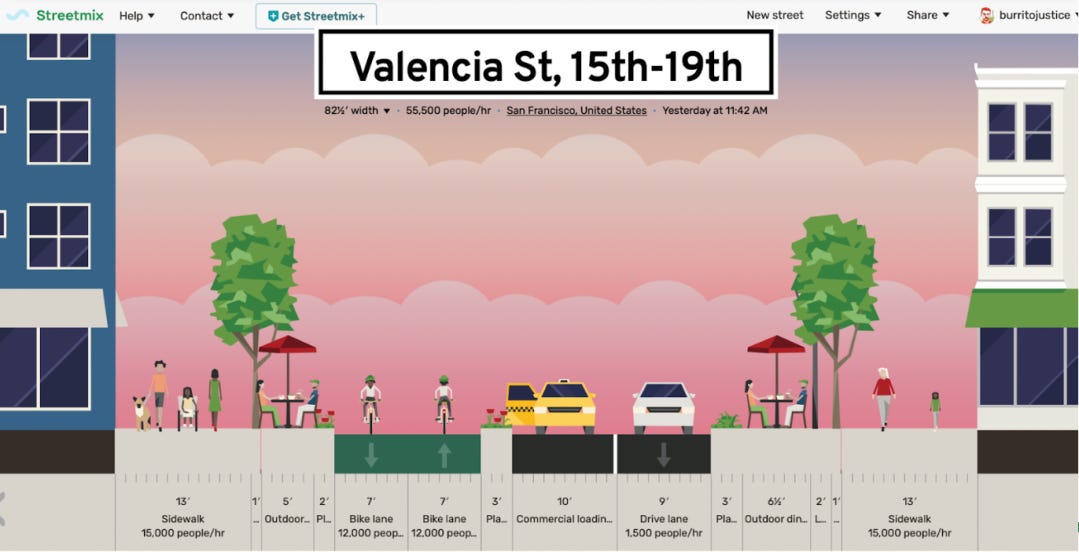
Mission Playground anchors the 800 block of Valencia Street between 19th and 20th in the Mission District. Valencia is the commercial stretch in the area, a marvelous case study in bustling boulevards. Shoulder to shoulder with local shops, eateries, and bars, the street is popular among Mission residents and the greater Bay Area community. There’s a problem though. For a long time, this corridor has been one of the most dangerous spots to bike in the city. SFMTA acknowledged the need for something more comprehensive on Valencia, and by 2019 the street received a much-needed intervention: parking-protected bike lanes from Market St to 15th St (2018-2019). Unfortunately, completing the Valencia route would have to wait due to COVID in 2020.
Through the COVID drone, bike activist Burrito Justice proposed the Burrito Plan (2022), a fun and functional rendering of Valencia born anew. The plan imagined the Mission drag with one-way traffic, a two-way bike lane on one side of the street, and an expanded commercial loading zone to serve businesses and separate bikes from faster-moving cars. The Burrito Plan also imagined a healthy dose of sidewalk extension and public seating to encourage active frontages and pedestrian traffic alá the famed cafe culture of European cities.
When SFMTA resumed the planning and design process for a new mid-Valencia Pilot in 2022, the Burrito Plan didn’t quite roll together (although it did receive a shoutout as an alternative in a 2024 evaluation update on the mid-Valencia Pilot). In August 2023, SFMTA landed on a one-year pilot in the form of a centered, two-way bike boulevard with opposite way traffic on either side separated by chunky plastic bollards. Yet six months later we’re back to the drawing board, as the center-running lane has not been widely embraced.
As seen with our 11th and Natoma Extension, the opportunity to reimagine the public realm is right in front of us. What if Mission Playground extended into Valencia? It would bolster this popular park, promote pedestrian and bike accessibility, and preserve all forms of mobility.
We present to you the Mission Playground Turnaround. The block between 19th and 20th Street on Valencia is home to businesses, bars, restaurants, and of course Mission Playground as its centerpiece. If reducing traffic while promoting bike and pedestrian safety and improving local businesses are among the primary goals for a re-imagined Valencia, this block would be opportune in doing so since a large portion of the block is already dedicated to public space.
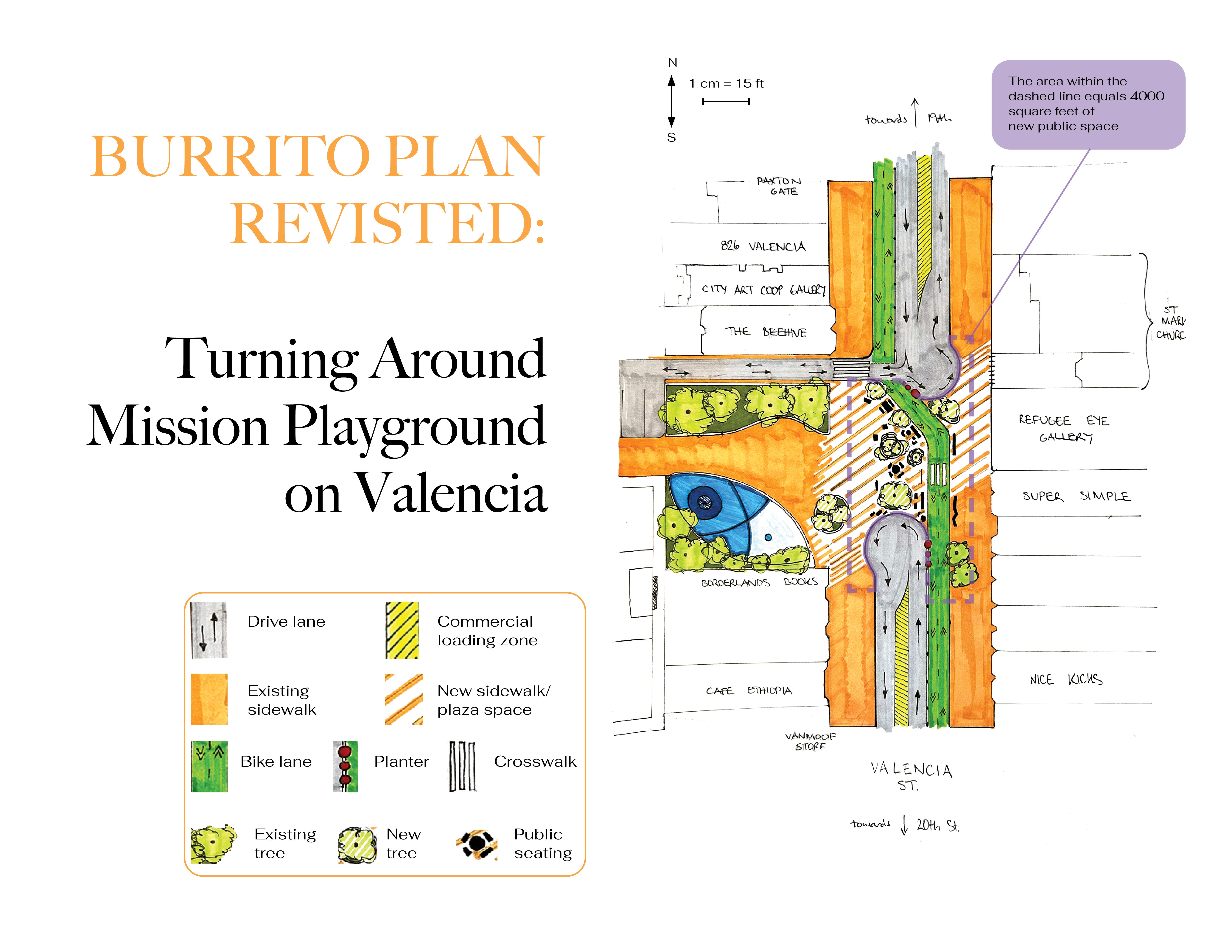
The park extension eliminates through traffic while ensuring that all of Valencia is still accessible to bikers, delivery drivers, fire trucks, and anyone else who needs to use it. Access to the Mission Playground parking lot and houses on Cunningham Place would be maintained. The turnarounds bookend a newly built plaza spanning the length of the playground. To allow for bikers and emergency vehicles, 12’ lane runs diagonally across the edge of the plaza, switching sides at the Mission Playground turnaround. The two-way bike lane (inspired by the Burrito Plan) would hug the west side of the street from Market to 19th, then switch to the east side 20th to Cesar Chavez—ensuring that the travel lane enables emergency vehicles to quickly enter the corridor from either direction when needed. A commercial loading and service vehicle zone is placed in the center of the turnarounds for traffic calming and fire access purposes.
Yet the real focus here is the Mission Playground extension itself. If adopted, the new area would add almost 4,000 square feet of adaptable public space that could be used for tree planting, gardening, public seating, parklets, you name it! The flexible extension space presents more opportunities for community activation: more room to eat, drink, gather, and enjoy Valencia Street safely. If a park extension can be an effective tool on some of our most congested streets, what could it do for some of our densest neighborhoods? We turn to the Tenderloin to find out.
Sergeant John Macaulay Park
The Tenderloin has an urgent need for open space access. The area north of Market is the most densely populated plot of San Francisco, with an estimated 27,000 residents crammed into 0.4 sq miles at a density of 69,230 people per square mile, almost 20,000 more than the population densities of other northeast neighborhoods. With just 3 small parks, the Tenderloin has, inversely, the lowest density of parks and open space in the city at just under 4% compared to a citywide 23%. As much as we can wave around that 23% as proof of one of the best parks systems in the nation, the spatial distribution of parks in the city complicates the picture of San Francisco’s outdoor success story. Our most urban neighborhoods are in the background of this picture and its time their demands for more livable and lively spaces were met.
New parks and open space projects can lead the way in mending neighborhood wounds and restoring equity to one of San Francisco’s most condensed and complex areas. We’ve already seen this trend in forward motion. In the words of Kate Robinson, leader of the Tenderloin CBD, “Our three small parks…are a lifeline for residents: welcoming, safe spaces for everyone that we have leveraged as critical community resource hubs.” We asked ourselves, how can we build on the work already being done in the Tenderloin?
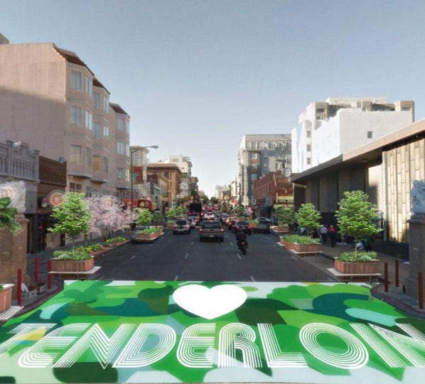
Given there are only three small parks in the Tenderloin, the options were slim in terms of finding a site suitable for an extension. However, Sgt. John Macaulay Park at the corner of Larkin and O’Farrell is ripe for public space experimentation. Larkin Street has already caught the eye of Tenderloin stakeholders, as the street lies at the heart of Little Saigon, home to more than 20 small businesses. This stretch was included in the Tenderloin Community Action Plan as the Larkin Green Canopy project. In an effort to re-invigorate the commercial corridor with foot traffic, the project will install two parklets as the spark for later tree planting and street light installation, stretching from Eddy to O’Farrell. Again…why stop there?
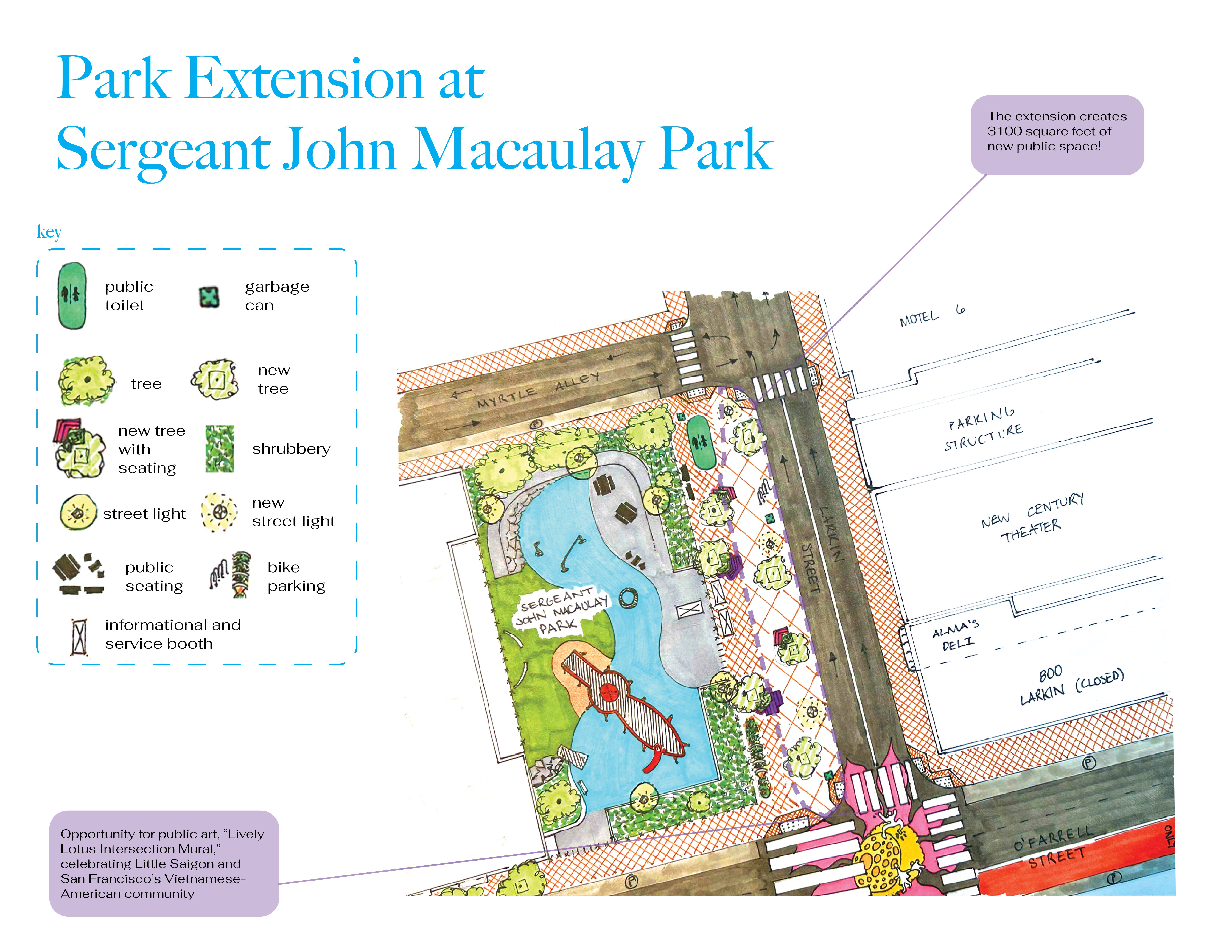
A park extension here would double as an extension of the Lakin Green Canopy project as well. Stretching out 20 ft into Larkin for the 150 ft block between Myrtle Alley and O’Farrell, the extension narrows the street to just two 12’ lanes, eliminating the third lane of through traffic. Minimizing the lanes will help slow traffic but for good measure, we added a crosswalk at Myrtle and an intersection mural at O’Farrell and Larkin to promote pedestrian connectivity and park access by making the area more human-scaled. In the extension, the magic continues. Planter-bench hybrids cozy up to new street trees keeping the Larkin Green scene going and expanding the urban canopy of the park itself. With 3100 feet of new public space (over a third of the park’s current area), the information and service tent stationed in Macaulay can be more street-facing to naturally engage passersby. The remaining space is dedicated to public amenities like flower beds, seating, and of course, more tree canopy for all the Tenderloin residents to enjoy.
In a city like San Francisco, known for its parks large and small, it’s easy to be complacent with the state of our public spaces. And if not complacent, overwhelmed with proposals for entirely new, capital-intensive, or disruptive projects. The funny thing is that public space projects do not have to be huge or novel undertakings. We don’t have to build a whole new park every time. In fact, incremental or additive changes to existing areas can be equally transformative, especially in cases where space is limited and margins are tight. Whether it be 11th and Natoma, Mission Playground, or Sgt. John Macaulay Park, working with what we have can be the first step forward in re-imagining San Francisco’s public realm. So, the next time you’re passing by your favorite park, playground, or garden, ask yourself: what if there was a little more park here?